The Capital Area Metropolitan Planning Organization has prepared a draft Regional Active Transportation Plan for the first time and the Transportation Policy Board is expected to vote on passage of the plan at its meeting tonight.
Some very excellent consultants worked on the project led by very capable staff. Together they have produced a document with important data, analysis, recommendations to improve active transportation options and systems across the region.
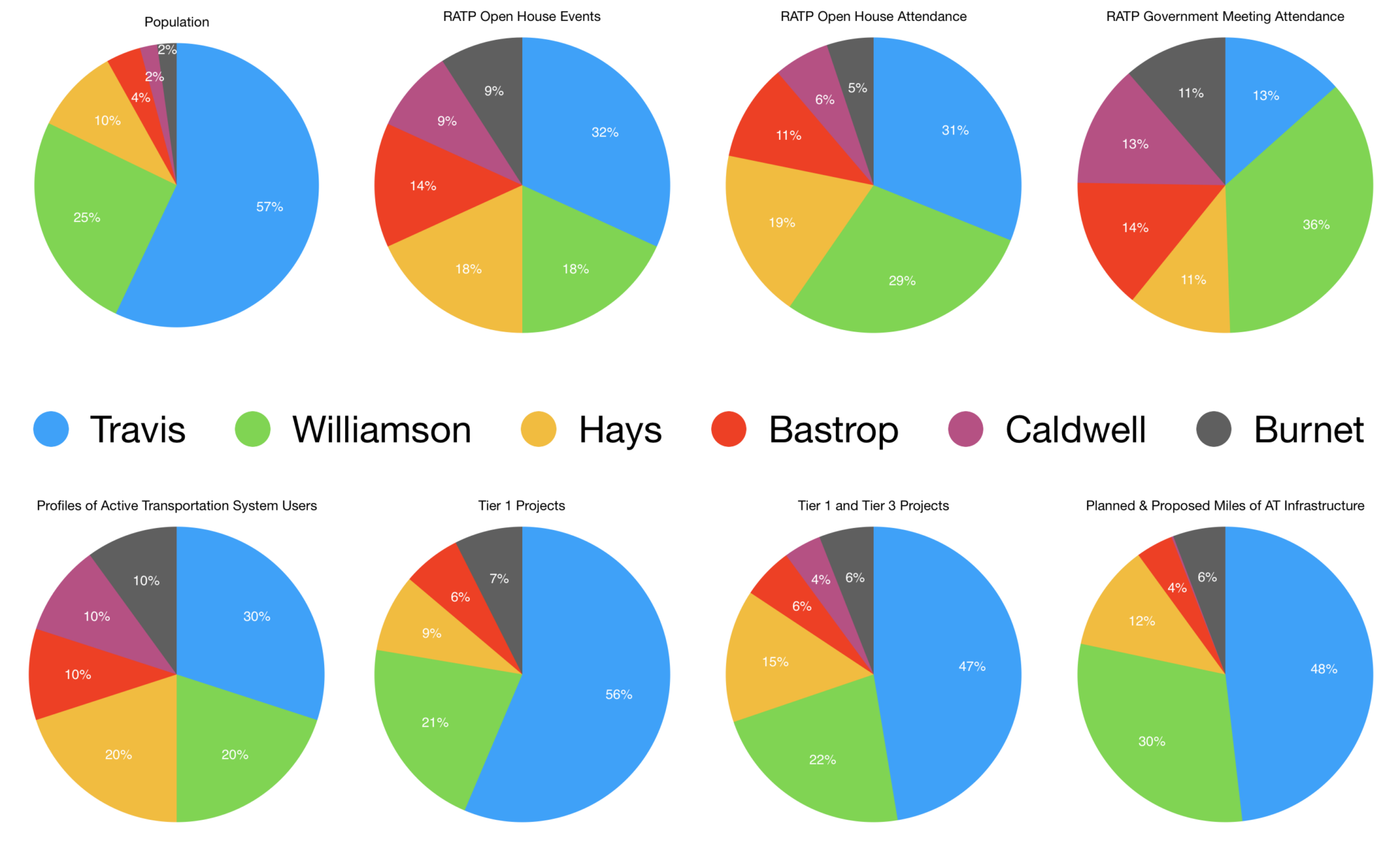
However, the structural geographic inequity at CAMPO seems to have hindered the effectiveness and benefit of this otherwise positive step forward. As shown in the charts above, every single metric I was able to look at from the report showed an underrepresentation of the residents of Travis County in this process and the resulting recommendations. The data is here.
300,000 more people live in Travis County than all other counties of the 6 county CAMPO region. Yet, more government staff were able to attend meetings on this plan in Williamson County alone than in Travis County.
While Travis County is shown with the most total number of miles of active transportation planned and proposed for any one county, more total miles were proposed outside the county than inside, for the area with 300,000 less people. While there are 11 projects proposed per 100,000 residents of Travis and Williamson County each, there are 19 per 100,000 residents in Hays and 35 per 100,000 residents of Burnet.
This brings potential serious concerns as CAMPO moves to add this plan into its performance measures and metrics for allocating regional transit funding, as explained in our letter sent in during the brief public comment period. We also explored the serious inequity issues at CAMPO year ago in our Special Report on Representation at CAMPO as well as in our broader Texas Transportation Equity Assessment.
While this Active Transportation Plan is a step forward and likely improves the overall picture at CAMPO, much work remains to be done for CAMPO to be able to produce an efficient, equitable, prosperous 2045 Regional Transportation Plan. To remedy similar inequity and inefficiency issues, the State of California recently restructured the voting system of SANDAG, CAMPO’s equivalent for the San Diego region. Perhaps similar broad measures are needed here.


How did you calculate the percentage counties for the projects (e.g. Tier 1, etc.)? Did you use mileage, segments?
The Tier 1 and Tier 2 graphs are just number of projects, while there is one based on Miles too.